(Des Moines) A Winter Storm Warning has been expanded to include Cass, Audubon, Shelby, Guthrie, Crawford, and Carroll counties, with hazardous conditions expected from 3:00 p.m. today through 6:00 a.m. Friday.

Meanwhile, the Winter Storm Warning remains in effect for Pottawattamie and Harrison counties from noon today until 6:00 a.m. Friday.
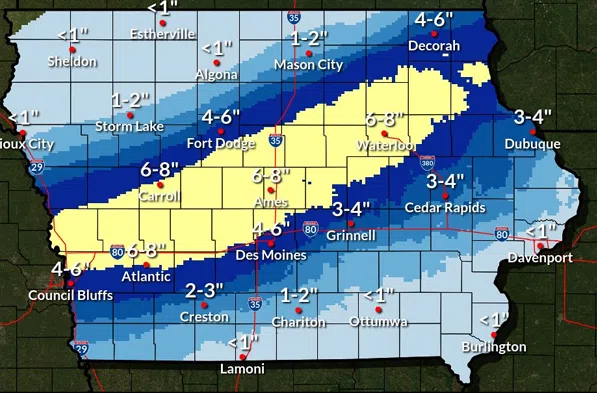
Forecasters say precipitation will spread from western into central Iowa this afternoon and evening. The system may begin as a rain-snow mix across southern and western portions of the state before transitioning fully to snow as temperatures drop.
A concentrated band of heavy snowfall is expected to develop from western through central into northeastern Iowa. By Friday morning, total accumulations of 5 to 8 inches are forecast in the warning area. Meteorologists caution that snowfall amounts could vary sharply over short distances, as even a slight shift in the storm’s track may significantly alter totals.
Snowfall rates could exceed one inch per hour at times this evening, leading to rapid accumulation on roads and quickly deteriorating travel conditions. Officials warn the storm is likely to impact the Thursday evening commute, with slick roads and reduced visibility expected.
Travel could become very difficult or hazardous overnight.
In addition to the warnings, a Winter Weather Advisory has been issued for Monona, Mills, Montgomery, Adair, Adams, and Union counties, where lighter but still impactful winter conditions are anticipated.
Residents are urged to monitor forecasts, allow extra travel time, and prepare for changing road conditions as the storm moves through the region.