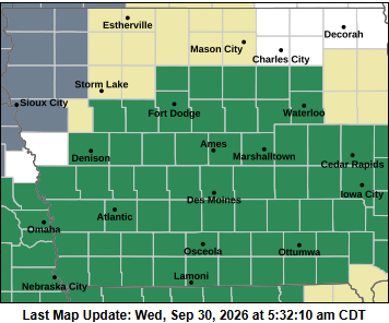
(Central Iowa) A prolonged period of showers and thunderstorms is expected to continue through Thursday evening, with heavy rainfall possible across parts of Iowa.
Forecasters say rainfall totals of 2 to 4 inches are expected in a southwest-to-northeast band across central Iowa, with locally higher amounts possible.
The rain will fall on already saturated soils, increasing the potential for flash flooding. Poor drainage areas and low-lying locations may also experience ponding.
The additional rainfall is expected to cause rises on area rivers, with some rivers potentially exceeding flood stage in at least a few locations.
Residents in areas prone to flooding should remain alert as the rain continues through Thursday evening.
The Flash Flood Watch for northern Iowa has been canceled.