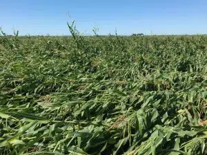
(Des Moines) Iowa State Climatologist Dr. Justin Glisan says the derecho that left significant crop and structural damage held together for 770-miles over fourteen hours before it lost its strength over western Ohio. Iowa Secretary of Agriculture Mike Naig and State Climatologist Dr. Justin Glisan held a press conference at 3:00 p.m. on Tuesday to provide an update on the derecho storm and the agricultural-related damage.
Glisan says the system produced wind speeds of 70 to 90- miles per hour, with the strongest gust of 106 miles per hour near Le Grand just east of Marshalltown. The devastating winds occurred mainly in the state of Iowa and lost strength as it entered Illinois, Indiana, and Ohio.
Glisan said the storm’s width covered the central third of the state from west to east. He says as the line moved past Carroll, that is where the wind began to intensify.
Iowa State Ag Secretary Mike Naig says the storm impacted roughly a third of the state.
Naig says tens of millions of commercial grain storage and millions of on-farm grain storage were destroyed or severely damaged. In addition to that, just like the cities impacted across the state, farms and agricultural-businesses sustained structural damage, including; livestock buildings, machine sheds storing equipment, and of course, a lot of tree damage. Naig says two of the most important conversations a farmer will have in the coming days will be with his crop insurance agent, and his agronomist, to determine what is happening with the damaged crop in the field.
Ag Secretary Naig says this next week will tell us a lot about the fate of the crop. He says a lot of corn is lying down, and will not be harvested, while other fields will still produce a crop.

Naig says there is still a lot to learn about the extent of the damage.


