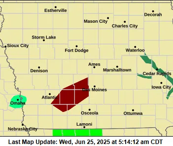
(Des Moines) — The National Weather Service in Des Moines has issued a Flash Flood Warning for several counties across central and southwestern Iowa, in effect until 10:15 a.m. CDT this morning.
Counties under the warning include southern Dallas, Madison, northwestern Union, Adair, northern Adams, southeastern Cass, and southeastern Guthrie.
At 5:13 a.m., Doppler radar and automated rain gauges detected heavy thunderstorms across the region, with rainfall totals ranging from 2 to 4 inches already recorded. Forecasters predict an additional 1 to 2 inches of rain in the affected areas, which could increase the risk of flash flooding.
Hazards and Impacts
The primary threat is flash flooding caused by excessive rainfall, particularly in small creeks and streams, low-lying areas, urban streets, and locations with poor drainage. The flooding may also impact highways and underpasses.
Communities at Risk
Areas expected to experience flash flooding include:
- West Des Moines
- Urbandale
- Clive
- Waukee
- Grimes
- Creston
- Winterset
- Adel
- Greenfield
- Stuart
- Dallas Center
- Earlham
- Granger
- De Soto
- Van Meter
- Redfield
- Adair
Flooding has already been reported along Interstate 80, particularly near mile markers 102 and 113, where standing water has been observed.
Safety Advisory
Authorities urge residents to remain alert and avoid driving through flooded roadways. The message from the National Weather Service is clear: “Turn around, don’t drown.” Most flood-related fatalities occur in vehicles attempting to cross high water.
For the latest updates on river levels and flood conditions, visit weather.gov/desmoines/water.
Residents are advised to monitor local alerts and stay informed as weather conditions evolve throughout the morning.