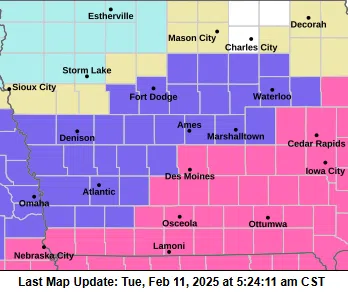
(Des Moines) The first widespread snowfall is forecast for midnight tonight over far western Iowa, spreading into central and eastern Iowa after midnight. While snow is expected statewide, the highest snow accumulations will be over Iowa’s southern, central, and southeastern portions, with five to eight inches expected. The state’s southwest region is forecast to receive three to five inches of snow.
Snow-covered and slick roads should be expected, and travel can be hazardous. Snow rates will generally be a quarter to half an inch per hour, though there will be a few periods when rates will be half an inch to three-quarters per hour.
While visibility will be reduced in falling snow, blowing snow will not be a significant issue, with wind speeds averaging 10 to 15 mph. The snow will taper off from west to east late Wednesday afternoon into Wednesday evening.
A Winter storm warning goes into effect at midnight tonight for extreme southern, central, and southeast Iowa. A Winter Weather Advisory is in effect for much of southwest Iowa from midnight tonight to midnight on Wednesday.