(Sioux Falls, South Dakota) In Sioux Falls, South Dakota, Matthew Dux, Lead Meteorologist with the National Weather Service, tells KSOM/KS95 News that heavy rainfall of a foot or more across many parts of northwest Iowa has caused historic flooding.
Dux mentioned that the heavy rainfall has set numerous river flood records in the state’s northwest region. Starting last Wednesday, five to ten inches of rainfall drenched the Lakes area, with five to six inches falling within 12 hours. Rock Valley, Iowa, received six to 12 inches of rainfall, while areas near the Big Sioux River, just across the border from northwest Iowa, saw 12 to 14 inches of rain.
Dux updated us that some rivers are cresting. Still, the water will take a few days to recede, especially in residential and low-lying areas surrounding the rivers in northwest Iowa. Dux says there are numerous road closures in this region due to flooding.
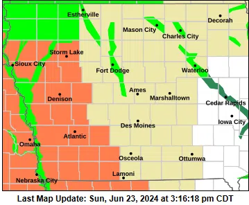
The National Weather Service in Des Moines reports other river basins of most concern.
*West Fork Des Moines River Some crests would be near records and surpass those in 1993.
*East Fork Des Moines River Some crests would be the third highest in history.
*Des Moines River mainstem above Saylorville Lake
*Cedar – Winnebago Rivers Note: the high-water levels will expand to include more locations over the next several days as the water moves downstream.
The Flood Warning continues for the following rivers in Nebraska…Iowa…Missouri…
*Missouri River At Nebraska City, Fremont, and Otoe Counties.
*The Missouri River at Plattsmouth- Mills and Cass Counties.
*Missouri River At Decatur-Burt, Thurston, and Monona Counties.
*Missouri River Near Blair, Harrison, Washington, and Pottawattamie counties.
*Missouri River At Brownville, Atchison, and Nemaha Counties.
*Missouri River At Omaha, Douglas, Sarpy, and Pottawattamie counties.
*Missouri River At Rulo, Holt and Richardson Counties.


