(Area) The rainy storm pattern is expected to continue into the weekend, with some relief possibly next week, according to the National Weather Service in Des Moines.
Mark Debruin, a meteorologist with the National Weather Service in Des Moines, says the rainy and stormy weather pattern will continue through the weekend.
Debruin says the culprit is the large amount of moisture in the air that will not go away, along with a stubborn high-pressure system just to the south, and Iowa is sitting on the edge of that system. Debruin says a series of low-pressure systems continues to train over that high-pressure system, causing copious rainfall. There is a chance of more rain tonight, Thursday, with dry conditions during the day on Friday; however, storms may put a damper on high school football games on Friday night. He says the wet weather will begin around 7:00 p.m. on Friday.
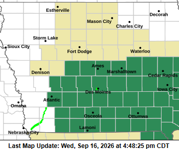
A Flood Watch remains in effect through Thursday morning for portions of central and southern Iowa as additional heavy rainfall could lead to flash flooding.
Audubon, Cass, Adams, and Taylor Counties are on the western edge of this Flood Watch.
Showers are ongoing across parts of the region, with a band of heavier rain expected overnight. Already saturated ground conditions mean less additional rainfall is needed to produce flooding.
Excessive runoff could cause flooding in rivers, creeks, streams, and other low-lying, flood-prone areas. Residents should remain alert to changing weather conditions and be prepared for possible flooding, especially overnight.
Wednesday evening