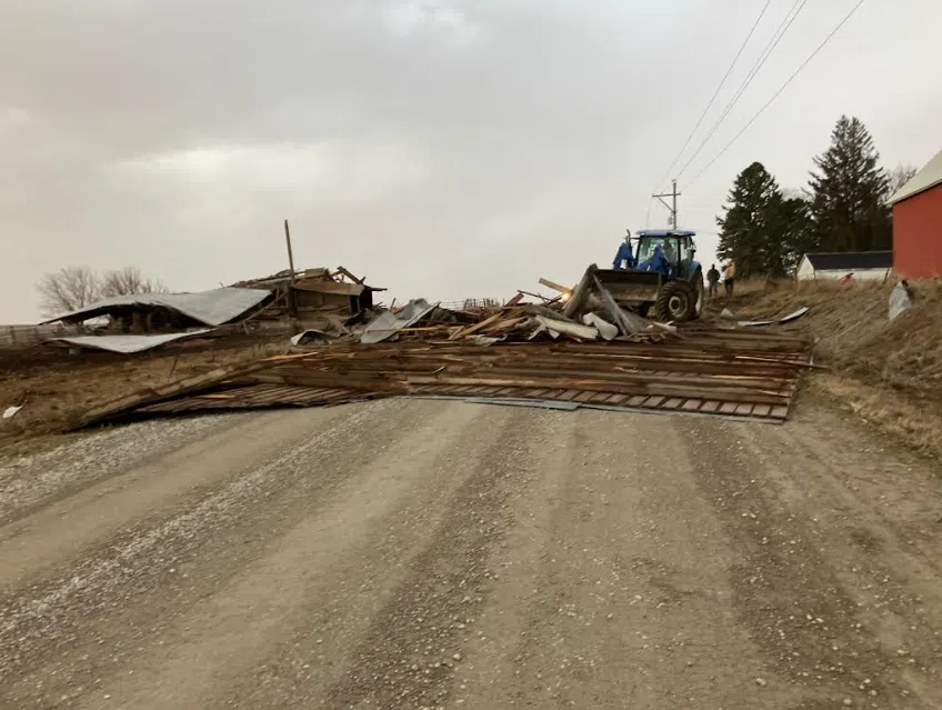
(Area) High winds caused damage in southwest and central Iowa late Friday. The storm downed power lines, and scattered debris in several areas of the region. High winds downed power lines, and stop lights in Creston. A 69 mile per hour wind gust was reported nine miles east of Griswold. The photo is wind damage south of 620th and Memphis Road in Cass County. The photo was provided to KSOM KS95 News by Cass County Emergency Management Coordinator Mike Kennon.
The National Weather Service reported the following incidents.
0409 PM Hail 1 N Bridgewater 41.26N 94.67W
03/14/2025 E1.00 Inch Adair IA Trained Spotter
0417 PM Hail Brayton 41.54N 94.93W
03/14/2025 M1.25 Inch Audubon IA Broadcast Media
0420 PM Hail Adair 41.50N 94.64W
03/14/2025 E1.50 Inch Adair IA Public
0432 PM Hail 3 E Exira 41.59N 94.82W
03/14/2025 M0.88 Inch Audubon IA Emergency Mngr
0444 PM Hail 3 E Winterset 41.32N 93.95W
03/14/2025 E0.75 Inch Madison IA Public
0448 PM Hail 10 W Guthrie Center 41.67N 94.69W
03/14/2025 E0.88 Inch Guthrie IA Law Enforcement
0450 PM Hail 1 S Van Meter 41.51N 93.95W
03/14/2025 E0.50 Inch Dallas IA Public
0451 PM Hail 1 SW Van Meter 41.52N 93.97W
03/14/2025 E0.75 Inch Dallas IA Public
0453 PM Tstm Wnd Gst 2 ENE Lamoni 40.63N 93.90W
03/14/2025 M62 MPH Decatur IA ASOS
0454 PM Tstm Wnd Gst 2 ENE Lamoni 40.63N 93.90W
03/14/2025 M71 MPH Decatur IA ASOS
0458 PM Hail 1 W Waukee 41.61N 93.89W
03/14/2025 E0.70 Inch Dallas IA Trained Spotter
0459 PM Tstm Wnd Gst 9 ESE Griswold 41.18N 94.98W
03/14/2025 M69 MPH Cass IA Public
0527 PM Tstm Wnd Dmg 2 S Menlo 41.50N 94.41W
03/14/2025 Adair IA Fire Dept/Rescue
semi that was blown over on I-80 at the 86 mile marker near Menlo.
0528 PM Tstm Wnd Gst 2 S Menlo 41.50N 94.40W
03/14/2025 E70 MPH Adair IA Emergency Mngr
0541 PM Tstm Wnd Dmg Guthrie Center 41.68N 94.50W
03/14/2025 Guthrie IA Trained Spotter
Roof blown off of a storage building. Time
estimated.
0541 PM Tstm Wnd Dmg Guthrie Center 41.68N 94.50W
03/14/2025 Guthrie IA Emergency Mngr
apartment buildings lost their roofs in Guthrie Center – time estimated by radar.
0552 PM Tstm Wnd Gst Des Moines Int Airport 41.53N 93.66W
03/14/2025 M63 MPH Polk IA ASOS
0557 PM Tstm Wnd Gst 3 WSW Glidden 42.05N 94.79W
03/14/2025 M64 MPH Carroll IA AWOS
0558 PM Tstm Wnd Dmg 4 WNW Carroll 42.09N 94.94W
03/14/2025 Carroll IA Broadcast Media
1/2 mile of power poles snapped off 3 m west
and 1 mi north of Carroll near the town of
Maple River. Time estimated.
0600 PM Tstm Wnd Gst 3 SW Denison 41.99N 95.38W
03/14/2025 M59 MPH Crawford IA AWOS