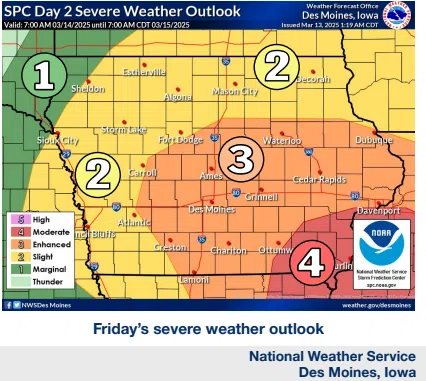
(Des Moines) Severe storms are likely on Friday afternoon and evening, with damaging winds being the main threat. There is also some risk for tornadoes and large hail, but to a lesser extent.
The storms are expected to occur primarily between 4 PM and 10 PM, rushing at 50-60 mph. Strong winds are anticipated even outside thunderstorms, particularly from the south-southeast, which may gust up to 45 mph across southern and eastern Iowa, creating near-critical fire weather conditions. Saturday will see brisk winds as well, though not as intense.
As the storms pass through, there will be a brief opportunity for tornadic activity, with the highest likelihood of significant tornadoes (EF2+) in southeastern areas. Hail sizes could range from 0.75 inches (penny) to as large as 2.75 inches (baseball), with the greatest chances for hail exceeding 2 inches in southeast Iowa. The biggest severe weather concern remains damaging winds, with gusts reaching 74 mph or more possible throughout central Iowa.