


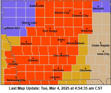
(Des Moines) A strong early spring system is set to affect Iowa later today through tonight into Wednesday. The National Weather Service in Des Moines issued a Blizzard Warning for all of southwest, and portions of west central Iowa from 9:00 p.m. this evening to 3:00 p.m. on Wednesday.
Rain will quickly change to snow from northwest Iowa to southeast Iowa overnight as winds intensify from the northwest and become strong with gusts near or above 60 mph.
The combination of these winds with falling snow will cause significant visibility reductions, and a period of blizzard conditions is expected. Blowing and drifting snow with whiteout conditions, particularly in open, rural areas, will make travel dangerous tonight into at least part of Wednesday morning. Even as the falling snow ends, blowing snow and visibility restrictions may persist. Conditions are expected to improve later Wednesday as the winds slowly decrease.
Click the space bar below to hear National Weather Service Meteorologist Jim Lee’s comments regarding the storm


